 Hurricane Ian Advisory #4 September 28, 2022 – 6:00 pm Hurricane Ian made landfall along the Florida Gulf Coast on the afternoon of Wednesday, September 28, 2022, as a strong Category 4 hurricane with maximum sustained winds of 150 mph. Hurricane Ian is now moving northeast across the state of Florida and is expected to emerge into the Atlantic Ocean on Thursday. There is still uncertainty with the track and intensity of the storm after it emerges from the east coast of Florida. Because Ian is now forecast to be over the Atlantic Ocean for a longer period of time, there is an increased possibility of hurricane force winds in our area. Earlier today, the National Weather Service (NWS) issued a Hurricane Watch for coastal counties, including Charleston County. The area also remains under a Tropical Storm Warning and Storm Surge Warning. According to NWS Charleston, there is high confidence that Hurricane Ian will impact our area. Below is a summary of today’s report from NWS Charleston:
On Wednesday afternoon, Governor Henry McMaster declared a statewide State of Emergency effective at 3:00 pm on Wednesday, September 28th. The Governor has not issued an evacuation order. During a press conference on Wednesday afternoon, representatives from the Charleston County Emergency Management Department (CCEMD) encouraged residents in low-lying and flood prone areas to consider relocating during the storm. CCEMD representatives also announced the following actions in advance of Hurricane Ian:
As of Wednesday afternoon, the Town of Seabrook Island has also moved its operational status to OPCON 2 (Enhanced Readiness / Disaster Impacts Likely). Town offices will close at 12:00 pm on Thursday, September 29th, and will remain closed on Friday, September 30th. Beach patrol services will also be suspended on Friday, September 30th. Residents, property owners, and visitors are advised to monitor local media outlets for updates on Hurricane Ian and to make early preparations for potential storm impacts, including possible power outages. Forecasts are also updated regularly on the National Hurricane Center website at www.hurricanes.gov. As conditions in our area begin to deteriorate, individuals are encouraged to heed the following recommendations:
The next Town advisory is anticipated to be distributed on the afternoon of Thursday, September 29th, unless conditions warrant an earlier update. Property owners and managers with rental guests should forward this information to their rental guests. Owners and managers of commercial establishments are also encouraged to share this information with their employees. ======== Official updates from the town will be posted on the following town channels, as warranted:
Sign up for the Town's emergency notification system CodeRED. If you are unsure if you are registered, you can re-register without receiving duplicate notices. Be sure to opt-in for severe weather warning alerts. Click here to register. In the event of an emergency, please call 911. Emergency calls to 911 should be reserved for life-threatening situations, or for the reporting of a crime or fire. Do NOT call 911 if you have water in your home unless your life is in danger. Do NOT call 911 to report a power outage. Power outages should be reported directly to Berkeley Electric Cooperative. Hurricane Ian Advisory #3 September 27, 2022 – 5:00 pm As of 5:00 pm on Tuesday, September 27, 2022, Hurricane Ian is a category 3 hurricane with maximum sustained winds of 120 mph. The hurricane should remain in a favorable environment for strengthening over the next day or so while it moves over the warm waters of the southeastern Gulf of Mexico. While confidence in the storm track remains uncertain, current models predict Ian will make landfall on the Florida Gulf coast late Wednesday or early Thursday as a major hurricane. Earlier today, the National Weather Service (NWS) issued a Tropical Storm Watch and Storm Surge Watch for coastal South Carolina, from the Savannah River to the South Santee River. According to NWS Charleston, there is high confidence that Hurricane Ian will impact our area. Below is a summary of today’s report from NWS Charleston:
Residents, property owners and visitors are advised to monitor local media outlets for updates on Hurricane Ian and to make early preparations for potential storm impacts, including possible power outages. Forecasts are also updated regularly on the National Hurricane Center website at www.hurricanes.gov. The Town of Seabrook Island remains at OPCON 3 (Normal Operating Conditions) as we continue to monitor Hurricane Ian. The next Town advisory is anticipated to be distributed on the afternoon of Wednesday, September 28th, unless conditions warrant an earlier update. Property owners and managers with rental guests should forward this information to their rental guests. Owners and managers of commercial establishments are also encouraged to share this information with their employees. ======== Official updates from the town will be posted on the following town channels, as warranted:
Sign up for the Town's emergency notification system CodeRED. If you are unsure if you are registered, you can re-register without receiving duplicate notices. Be sure to opt-in for severe weather warning alerts. Click here to register. In the event of an emergency, please call 911. Emergency calls to 911 should be reserved for life-threatening situations, or for the reporting of a crime or fire. Do NOT call 911 if you have water in your home unless your life is in danger. Do NOT call 911 to report a power outage. Power outages should be reported directly to Berkeley Electric Cooperative. Hurricane Ian Advisory #2 September 26, 2022 – 3:00 pm On Monday, September 26, 2022, officials from the Town of Seabrook Island participated in a regional conference call with Charleston County Emergency Management Department (“CCEMD”) to receive an update on Hurricane Ian. Hurricane Ian was upgraded from a tropical storm on Monday morning. It is expected to rapidly intensify once it enters the Gulf of Mexico and is forecast to become a major hurricane on Tuesday. While confidence in the storm track remains uncertain, current models predict Ian to make landfall on the Florida Gulf coast late Thursday or early Friday. According to National Weather Service Charleston, the key takeaways from today’s call were as follows:
Residents, property owners and visitors are advised to monitor local media outlets for updates on Hurricane Ian and to make early preparations for potential storm impacts, including possible power outages. Forecasts are also updated regularly on the National Hurricane Center website at www.hurricanes.gov. The Town of Seabrook Island remains at OPCON 3 (Normal Operating Conditions) as we continue to monitor Hurricane Ian. The next Town advisory is anticipated to be distributed after the CCEMD conference call on the afternoon of Tuesday, September 27th, unless conditions warrant an earlier update. Property owners and managers with rental guests should forward this information to their rental guests. Owners and managers of commercial establishments are also encouraged to share this information with their employees. ======== Official updates from the town will be posted on the following town channels, as warranted:
Sign up for the Town's emergency notification system CodeRED. If you are unsure if you are registered, you can re-register without receiving duplicate notices. Be sure to opt-in for severe weather warning alerts. Click here to register. In the event of an emergency, please call 911. Emergency calls to 911 should be reserved for life-threatening situations, or for the reporting of a crime or fire. Do NOT call 911 if you have water in your home unless your life is in danger. Do NOT call 911 to report a power outage. Power outages should be reported directly to Berkeley Electric Cooperative.  Tropical Storm Ian Advisory September 25, 2022 – 6:00 pm At 1:30 pm on September 25, 2022, officials from the Town of Seabrook Island participated in a regional conference call with Charleston County Emergency Management Department (“CCEMD”) to review the threat posed by Tropical Storm Ian. Owing to uncertainties in the forecast storm track, potential impacts to Seabrook Island remain difficult to accurately predict. The Town will continue to monitor storm activity. National Weather Service Charleston reported that possibly as early as Thursday and into Friday, the Charleston area may experience heavy rain (5-7 inches) and tropical storm force wind gusts. The area along the coast will feel the greatest impact. There is the potential for coastal flooding and beach erosion during that time. Seabrook Island residents are encouraged to monitor storm reporting and to make early preparations for potential storm impacts, including power outages. Residents, property owners and visitors are advised to monitor local media outlets for updates on Tropical Storm Ian. Forecasts are also updated regularly on the National Hurricane Center website at www.hurricanes.gov. The Town of Seabrook Island remains at OPCON 3 (Normal Operating Conditions) as we continue to monitor Tropical Storm Ian. The next Town advisory is anticipated to be distributed by 3:00 PM on Monday, September 26th, unless conditions warrant an earlier update. Property owners and managers with rental guests should forward this information to their rental guests. Owners and managers of commercial establishments are also encouraged to share this information with their employees. ======== Official updates from the town will be posted on the following town channels, as warranted:
Sign up for the Town's emergency notification system CodeRED. If you are unsure if you are registered, you can re-register without receiving duplicate notices. Be sure to opt-in for severe weather warning alerts. Click here to register. In the event of an emergency, please call 911. Emergency calls to 911 should be reserved for life-threatening situations, or for the reporting of a crime or fire. Do NOT call 911 if you have water in your home unless your life is in danger. Do NOT call 911 to report a power outage. Power outages should be reported directly to Berkeley Electric Cooperative.  Tropical Storm Elsa Advisory July 7, 2021 – 3:00 pm Tropical Storm Elsa made landfall along Florida’s Gulf Coast on Wednesday morning, July 7th. The storm will continue to affect northern Florida with heavy wind and rain before moving north into Georgia and the Carolinas. The maximum sustained winds are currently at 50 mph. The National Weather Service (NWS) has issued a Tropical Storm Warning for Coastal South Carolina, including Charleston County. The effects of Tropical Storm Elsa are expected to be felt in the Charleston region beginning on Wednesday evening. Tropical storm force winds are expected to arrive in our area during the overnight hours, with gusts of up to 40-45 mph possible. Tropical Storm Elsa has the potential to bring heavy rainfall on Wednesday evening through Thursday morning. Rainfall amounts are expected to range from 2 to 4 inches, with higher amounts in some areas. Wind gusts could result in minor damage to weak or diseased trees and other structures. Except for heavy rain at high tide, no significant coastal flooding impacts are anticipated. Beachgoers should be advised of the possibility of rip currents on Wednesday and Thursday. Residents, property owners and visitors are advised to monitor local media outlets for updates on Tropical Storm Elsa. Forecasts are also updated regularly on the National Hurricane Center website at www.hurricanes.gov. The Town of Seabrook Island remains at OPCON 3 (Normal Operating Conditions) as we continue to monitor Tropical Storm Elsa. Official updates from the town will be posted on the following channels, as warranted:
In the event of an emergency, please call 911. Emergency calls to 911 should be reserved for life-threatening situations, or for the reporting of a crime or fire. Do NOT call 911 if you have water in your home unless your life is in danger. Do NOT call 911 to report a power outage. Power outages should be reported directly to Berkeley Electric Cooperative. Property owners and managers with rental guests should forward this information to their rental guests. Owners and managers of commercial establishments are also encouraged to share this information with their employees. 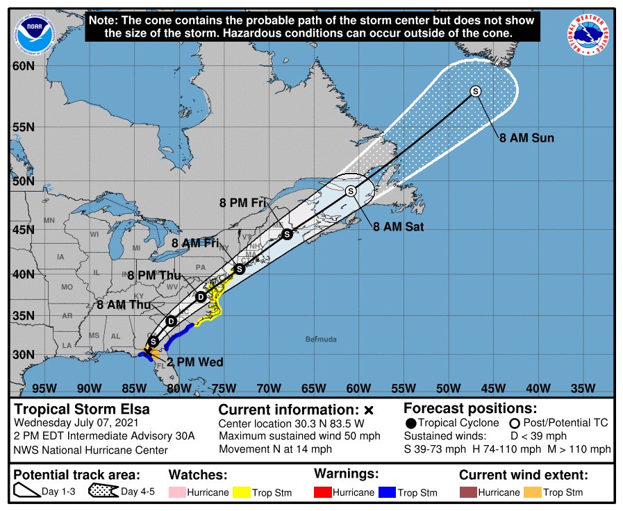 Tropical Storm Elsa Advisory July 6, 2021 – 3:00 pm The Town of Seabrook Island is currently monitoring Tropical Storm Elsa as it moves up the west coast of Florida. According to the National Weather Service, the storm is forecast to make landfall along the Florida Gulf Coast as a strong tropical storm or category 1 hurricane (74-95 mph winds). While the system is expected to weaken before moving into Georgia and South Carolina, the Charleston region is currently under a tropical storm watch. The main threats from Tropical Storm Elsa in our area will include heavy rains, flooding, rip currents and gusty winds beginning Wednesday evening and into Thursday morning. Residents, property owners and visitors are advised to monitor local media outlets for updates on Tropical Storm Elsa. Forecasts are also updated regularly on the National Hurricane Center website at www.hurricanes.gov. Property owners are encouraged to secure or remove outdoor objects like lawn furniture, garbage cans and other materials that may be blown by the wind. The Town of Seabrook Island remains at OPCON 3 (Normal Operating Conditions) as we continue to monitor Tropical Storm Elsa. Official updates from the town will be posted on the following channels, as warranted:
The Charleston County Citizen’s Information Line will be staffed on Wed. July 7th from 9:00 am to 5:00 pm. Residents who have questions about the storm can call (843) 746-3900. Spanish-speaking staff will be available as needed. In the event of an emergency, please dial 911. Property owners and managers with rental guests should forward this information to their rental guests. Owners and managers of commercial establishments are also encouraged to share this information with their employees. The next town advisory is anticipated to be distributed by 3:00 PM on Wednesday, July 7th, unless conditions warrant an earlier update. 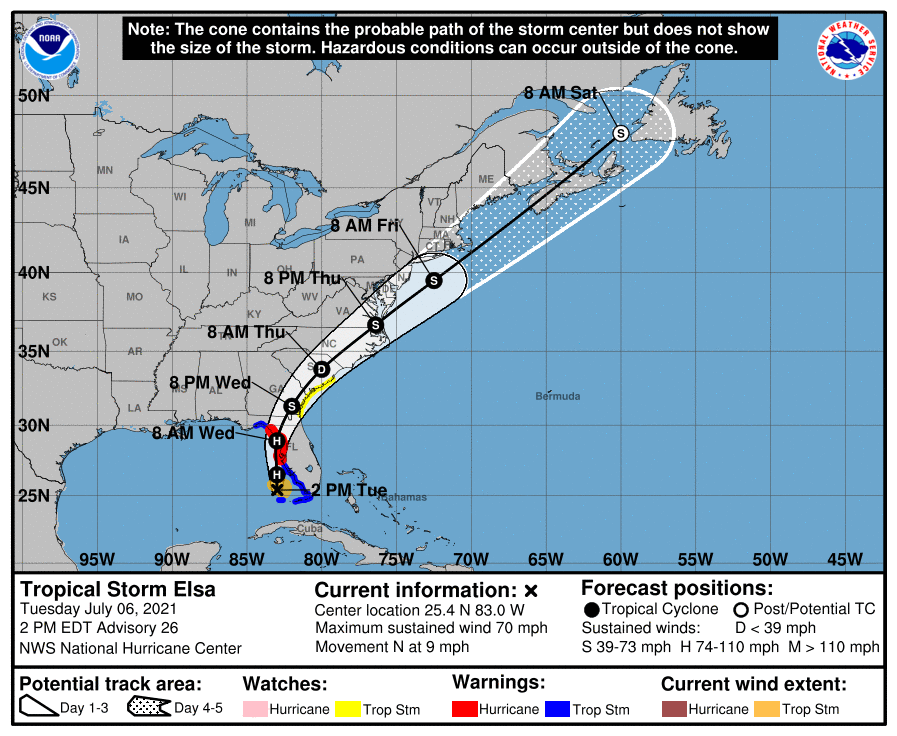  HURRICANE ISAIAS ADVISORY #6
August 4, 2020 -- 12:00 pm The outer bands of Hurricane Isaias brushed the coast of Charleston County during the afternoon hours of Monday, August 3rd. The center of the storm remained offshore, which resulted in lower wind speeds and rainfall amounts in the Charleston region. The National Weather Service upgraded Isaias from a tropical storm to a Category 1 hurricane at 5:00 pm on Monday, with maximum sustained winds of 85 mph. Hurricane Isaias made landfall near Ocean Isle Beach, NC, shortly after 11:00 pm on Monday. As of noon Tuesday, no significant damage has been reported on Seabrook Island and all roads leading to and from the island are clear of water and debris. The Town of Seabrook Island has resumed normal operating conditions and Town Hall re-opened for regular office hours (8:00 am to 4:00 pm) on Tuesday. The Town of Seabrook Island maintains lists of local contractors who are licensed to offer emergency blue tarp services (such as placing temporary protective coverings over damaged structures) and tree removal services following a hurricane or other disaster. If your home or property suffered damage as a result of the storm, please click here to view the town’s licensed contractor lists. This is the final advisory for Hurricane Isaias.  TROPICAL STORM ISAIAS ADVISORY #5
August 3, 2020 -- 2:00 pm On Monday afternoon, officials from the Town of Seabrook Island participated in a countywide conference call organized by the Charleston County Emergency Management Department (CCEMD). During the call, a meteorologist from the National Weather Service (NWS) Charleston Office briefed local officials on the current forecast for Tropical Storm Isaias. The key messages from this update were:
Seabrook Island Town Hall was CLOSED at 2:00 pm on Monday. At this time, town offices are expected to reopen at 8:00 am on Tuesday. If conditions warrant, any changes to the town’s operating hours will be posted on the town’s website and social media channels. Residents, property owners and visitors should continue to monitor local media outlets for updates on Tropical Storm Isaias. Forecasts are updated regularly on the NHC website at www.hurricanes.gov. Individuals are also to advised to avoid any unnecessary travel. In the event of an emergency, please call 911. Emergency calls to 911 should be reserved for life-threatening situations, or for the reporting of a crime or fire. Do NOT call 911 if you have water in your home unless your life is in danger. Do NOT call 911 to report a power outage. Power outages should be reported directly to Berkeley Electric Cooperative. The Town of Seabrook Island maintains a list of local contractors who are licensed to offer emergency blue tarp services (such as placing temporary protective coverings over damaged structures) and tree removal services following a hurricane or other disaster. To view a list of licensed contractors, please click here. Official updates regarding Tropical Storm Isaias from the Town of Seabrook Island will continue to be posted on the following channels:
Property owners and managers with rental guests should forward this information to their rental guests. Owners and managers of commercial establishments are also encouraged to share this information with their employees. The next town advisory is anticipated to be distributed by 2:00 PM on Tuesday, August 4th, unless conditions warrant an earlier update. TROPICAL STORM ISAIAS ADVISORY #4
August 2, 2020 -- 3:00 pm On Sunday afternoon, officials from the Town of Seabrook Island participated in another countywide conference call organized by the Charleston County Emergency Management Department (CCEMD). During the call, a meteorologist from the National Weather Service (NWS) Charleston Office briefed local officials on the current forecast for Tropical Storm Isaias. The key messages from this update were:
The Town of Seabrook Island has increased its emergency readiness status to reflect that tropical storm impacts are likely. At 1:30 pm today, the town convened a meeting of its Disaster Recovery Council to discuss continued preparations with community organizations and agencies. At this time, Seabrook Island Town Hall is expected to remain open for regular business hours on Monday (8:00 am to 4:00 pm). If conditions warrant, any change to the operational status of Town Hall will be posted on the town’s website and social media channels. At this time, residents, property owners and visitors are advised to monitor local media outlets for updates on Tropical Storm Isaias. Forecasts are updated regularly on the NHC website at www.hurricanes.gov. Residents, property owners and visitors are also encouraged to review their preparedness plans. Additional resources are available at the following links: Official updates regarding Tropical Storm Isaias from the Town of Seabrook Island will continue to be posted on the following channels:
In the event of an emergency, please dial 911. Property owners and managers with rental guests should forward this information to their rental guests. Owners and managers of commercial establishments are also encouraged to share this information with their employees. The next town advisory is anticipated to be distributed by 3:00 PM on Monday, August 3rd, unless conditions warrant an earlier update. HURRICANE ISAIAS ADVISORY #3
August 1, 2020 -- 3:00 pm Earlier this afternoon, officials from the Town of Seabrook Island again participated in a countywide conference call organized by the Charleston County Emergency Management Department (CCEMD). During the call, a meteorologist from the National Weather Service (NWS) Charleston Office briefed local officials on the current forecast for Hurricane Isaias. The key messages from this update were:
The Town of Seabrook Island has increased its emergency readiness status to reflect that tropical storm impacts are likely. At 1:30 pm today, the town convened a meeting of its Disaster Recovery Council to discuss continued preparations with community organizations and agencies. As Hurricane Isaias approaches, the South Carolina Emergency Management Division (SCEMD) encourages residents and property owners to review their personal safety plans and consider actions they would need to take if the storm threatens the state:
Residents, property owners and visitors are also encouraged to review their hurricane preparedness plans. Additional resources are available at the following links: Official updates regarding Hurricane Isaias from the Town of Seabrook Island will continue to be posted on the following channels:
Property owners and managers with rental guests should forward this information to their rental guests. Owners and managers of commercial establishments are also encouraged to share this information with their employees. The next town advisory is anticipated to be distributed by 3:00 PM on Sunday, August 2nd, unless conditions warrant an earlier update. |
Archives
January 2024
Categories
All
|
- About
-
Government
-
Meetings
-
Agendas & Minutes
>
- Town Council
- ATAX Advisory Committee
- Board of Zoning Appeals
- Community Promotion & Engagement Committee
- Environment & Wildlife Committee
- Planning Commission
- Public Safety Committee
- Public Works Committee
- Special Committee on ARPA Expenditures
- Special Committee on Finance
- Special Committee on Short-Term Rentals
- Utility Commission
- Public Comments >
- Short-Term Rental Study >
-
Agendas & Minutes
>
-
Services
- News & Events
- Links
- Contact
 RSS Feed

|
Town of Seabrook Island
2001 Seabrook Island Road Seabrook Island, SC 29455 Phone: (843) 768-9121 Email: [email protected] Town Hall Hours: M-F 8:00 am to 4:00 pm Privacy Policy |
|