 HURRICANE ISAIAS ADVISORY #2
July 31, 2020 -- 5:00 pm Earlier this afternoon, officials from the Town of Seabrook Island participated in a countywide conference call organized by the Charleston County Emergency Management Department (CCEMD). During the call, a meteorologist from the National Weather Service (NWS) Charleston Office briefed local officials on the current forecast for Hurricane Isaias. The key messages from this update were:
The Town of Seabrook Island has increased its emergency readiness status to reflect that tropical storm impacts are likely. At 2:00 pm today, the town met with representatives from SIPOA, Seabrook Island Utility Commission, Seabrook Island Club, St. Christopher Camp and Conference Center, Seabrook Island CERT, and others comprising the town’s Disaster Recovery Council to review storm development, likely impacts and preparations within the community. At this time, residents, property owners and visitors are advised to monitor local media outlets for updates on Hurricane Isaias. Forecasts are updated regularly on the NHC website at www.hurricanes.gov. Residents, property owners and visitors are also encouraged to review their hurricane preparedness plans. Additional resources are available at the following links: During a press conference this afternoon, Governor Henry McMaster stated that an evacuation order is not being contemplated at this time. Those who prefer to evacuate voluntarily for health or safety reasons should consider making early arrangements for a suitable location. Please keep in mind that the availability of accommodations (including hurricane shelters) may be adversely impacted by staffing or space limitations attributable to the ongoing COVID-19 pandemic. Charleston County has indicated that it may begin transportation services to emergency shelters as early as noon on Saturday, August 1st, if shelters are deemed necessary. If you need assistance with evacuation, or if you know a resident who may require assistance, please contact the town by phone at (843) 768-9121 or by email at [email protected] with the name(s), address(es) and contact information for those individuals. Official updates regarding Hurricane Isaias from the Town of Seabrook Island will continue to be posted on the following channels:
Property owners and managers with rental guests should forward this information to their rental guests. Owners and managers of commercial establishments are also encouraged to share this information with their employees. The next town advisory is anticipated to be distributed by 3:00 PM on Saturday, August 1st, unless conditions warrant an earlier update. Hurricane Isaias Advisory #1 July 31, 2020 -- 9:00 am According to the National Hurricane Center (NHC), Isaias was upgraded from a tropical storm to a Category 1 hurricane shortly before midnight on Thursday, July 30th, with maximum sustained winds of 80 mph. While Hurricane Isaias is currently centered between Cuba and the Bahamas, current forecasts from the NHC indicate that the storm could impact the South Carolina coast on Monday, August 3rd, with wind, heavy rainfall and coastal flooding possible. The detailed forecast for the track and intensity remain uncertain, and it is too soon to determine the exact magnitude and location of any potential impacts. The Town of Seabrook Island’s emergency readiness status remains at Operations Condition 3 (OPCON 3 - Normal Operating Conditions) and we are continuing to monitor guidance from local, state and national officials regarding development and potential impacts of the storm. At this time, residents, property owners and visitors are advised to monitor local media outlets for updates on Hurricane Isaias. Forecasts are also updated regularly on the NHC website at www.hurricanes.gov. Residents, property owners and visitors are also encouraged to review their hurricane preparedness plans. Additional resources are available at the following links: While an evacuation order is not anticipated at this time, residents and visitors should consider making arrangements for a suitable evacuation location should an order be issued. Please keep in mind that the availability of accommodations (including hurricane shelters) may be adversely impacted by staffing or space limitations attributable to the ongoing COVID-19 pandemic. If you need assistance with evacuation, or if you know a resident who may require assistance, please contact the town by phone at (843) 768-9121 or by email at [email protected] with the name(s), address(es) and contact information for those individuals. Official updates regarding Hurricane Isaias from the Town of Seabrook Island will continue to be posted on the following channels:
Property owners and managers with rental guests should forward this information to their rental guests. Owners and managers of commercial establishments are also encouraged to share this information with their employees. The next town update is anticipated to be distributed by 5:00 PM on Friday, July 31st. 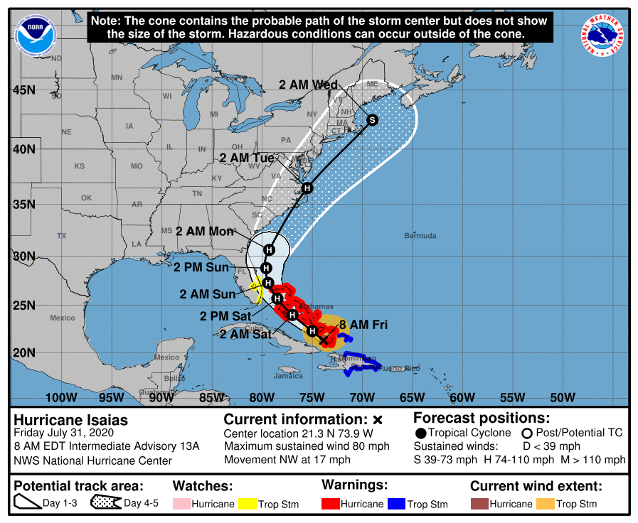  During an emergency meeting this afternoon, Charleston County Council adopted an ordinance declaring the existence of a State of Emergency due to civil unrest. As part of this ordinance, the county has imposed a curfew between the hours of 6:00 pm on Mon. June 1st and 6:00 am on Tue. June 2nd. This curfew will apply only to unincorporated areas of the county (ie. outside the corporate limits of a city or town).
As of 4:30 pm today, several municipalities throughout the county have implemented (or are in the process of implementing) curfews, including: Charleston, North Charleston, Mount Pleasant, Folly Beach, Isle of Palms, Kiawah Island and Sullivans Island. Some municipal curfews will begin at 6:00 pm, while others are expected to start at 8:00 or 9:00 pm this evening. At this time, the Mayor has not imposed a curfew within the town limits of Seabrook Island. The town will continue to monitor the ongoing situation and will distribute additional information if circumstances warrant. Residents and visitors who are planning to drive to or from Seabrook Island between Monday evening and early Tuesday morning are strongly advised to check with local authorities before departing so as to avoid violating a county or municipal curfew. As a reminder, all areas of Johns Island and West Ashley will be subject to Charleston city and county curfews. Stores and restaurants at Freshfields Village, which is located in the town limits of Kiawah Island, may also close early due to an expected curfew in Kiawah Island. For more information about the Charleston County curfew, please visit the Charleston County website. To view the county's emergency ordinance, please click here. Property owners and managers with rental guests should forward this information to their rental guests. Owners and managers of commercial establishments within the town, especially those with employees who reside in an area subject to a curfew, are also encouraged to share this information with their employees. In conjunction with curfews issued by the City of Charleston and the City of North Charleston, Charleston County Council has issued a countywide curfew from 6:00 pm on Sunday, May 31st, until 6:00 am on Monday, June 1st. The Town of Seabrook Island is located within Charleston County and is subject to this curfew.
A curfew requires people to stay indoors during the hours of the curfew; however, employees are permitted to travel to and from their places of employment. Residents and visitors of Seabrook Island are advised to stay indoors between 6:00 pm and 6:00 am to avoid violating the countywide curfew. Businesses may prefer to close so as not to encourage the public to be travelling to and from their places of business. For more information, please visit the Charleston County website. Property owners and managers with rental guests should forward this information to their rental guests. Owners and managers of commercial establishments within the town are also encouraged to share this information with their employees. The National Hurricane Center issued the following bulletin regarding Tropical Storm Bertha at 8:30 AM on Wednesday, May 27, 2020: TROPICAL STORM BERTHA FORMS NEAR THE COAST OF SOUTH CAROLINA TROPICAL STORM WARNING ISSUED AND HEAVY RAINFALL EXPECTED SUMMARY OF 8:30 AM EDT INFORMATION
WATCHES AND WARNINGS A Tropical Storm Warning is in effect for the coast of South Carolina from Edisto Beach to South Santee River. A Tropical Storm Warning means that tropical storm conditions are expected somewhere within the warning, in this case in the next few hours. For storm information specific to your area, including possible inland watches and warnings, please monitor products issued by your local National Weather Service forecast office. DISCUSSION AND OUTLOOK At 8:30 AM EDT, the center of Tropical Storm Bertha was located near latitude 32.7 North, longitude 79.4 West. Bertha is moving toward the northwest near 9 mph (15 km/h) and this motion is expected to continue through tonight. On the forecast track the center of Bertha will move onshore in the warning area in the next few hours and the move inland across eastern and northern South Carolina later today and into west-central North Carolina by tonight. Maximum sustained winds are near 45 mph (75 km/h) with higher gusts. Bertha is expected to weaken to a tropical depression after moving inland and become a remnant low tonight. Tropical-storm-force winds extend outward up to 25 miles (35 km) from the center. The estimated minimum central pressure is 1009 mb (29.80 inches). HAZARDS AFFECTING LAND RAINFALL: Bertha is expected to produce total rain accumulation of 2 to 4 inches with isolated totals of 8 inches across eastern and central South Carolina into west central to far southeastern North Carolina and southwest Virginia. This rainfall may produce life-threatening flash flooding. WIND: Tropical storm conditions are expected to reach the coast within the warning area in the next couple of hours. For more information, please visit the National Hurricane Center website. Property owners and managers with rental guests should forward this information to their rental guests. 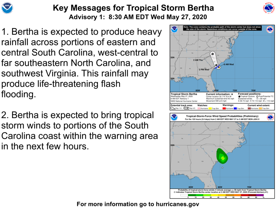 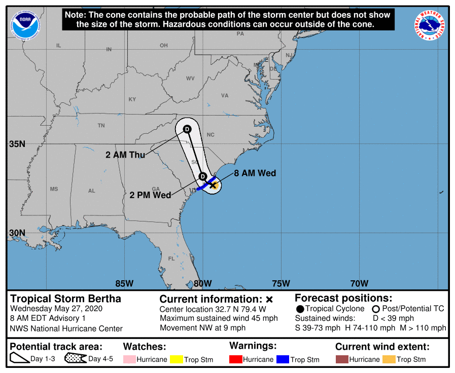 April 16, 2020 -- 9:00 pm Following the severe weather event that took place on Monday, April 13, 2020, the National Weather Service (NWS) Charleston Office conducted a damage survey to determine whether a tornado touched down within the Town of Seabrook Island. The results of the damage survey were released by the NWS at 5:40 pm on Thursday, April 16th. The NWS has confirmed that an EF-1 tornado occurred within the Town of Seabrook Island at approximately 8:28 AM on Monday, April 13th. Based on their observations, the NWS estimated that the tornado had a maximum wind speed of 105 mph. The tornado traveled approximately 1.25 miles and had a maximum path width of 120 yards. A summary of NWS damage survey is included below. NWS Damage Survey for April 13, 2020 Tornado Event
In addition to the tornado which was confirmed on Seabrook Island, the NWS determined that the same storm produced tornadoes at Edisto Beach at 8:15 AM (EF-2; 125 mph) and Kiawah Island at 8:33 AM (EF-1; 105 mph). As of 6:00 pm on Thursday, April 16th, the NWS has confirmed at least 9 tornadoes across the state of South Carolina as a result of Monday’s severe weather event. The storm resulted in the deaths of at least 9 people in South Carolina, and more than 1,000 homes were damaged or destroyed. More Information: View NWS Damage Survey for Seabrook Island & Kiawah Island Blue Tarp & Tree Removal Contractors The Town of Seabrook Island maintains a list on its website of licensed local contractors who offer emergency “blue tarp” and tree removal services following a hurricane, tornado or other disaster event. Please note that all contractors operating within the Town of Seabrook Island are required to have a valid town business license. To verify the license status of a contractor who is not on the town's emergency contractor lists, or to report an unlicensed contractor doing business within the town, please contact Town Hall by phone at (843) 768-9121 or by email at [email protected]. More Information: Town of Seabrook Island Emergency Contractor Lists Send Us Your Pictures Do you have pictures of damage or debris from Monday’s tornado? We are currently collecting photos to help document this event. Residents may send digital photos by email to [email protected]. Please include your name in the body of the message, as well as the approximate location where each photo was taken. Seabrook Island Town Hall Closed As a reminder, Town Hall remains closed due to the COVID-19 pandemic. Members of town staff are working remotely to provide “virtual services” to residents and business owners. For assistance during normal operating hours (Monday to Friday, 8:00 am to 4:00 pm), please contact us by phone at (843) 768-9121 or by email at [email protected]. 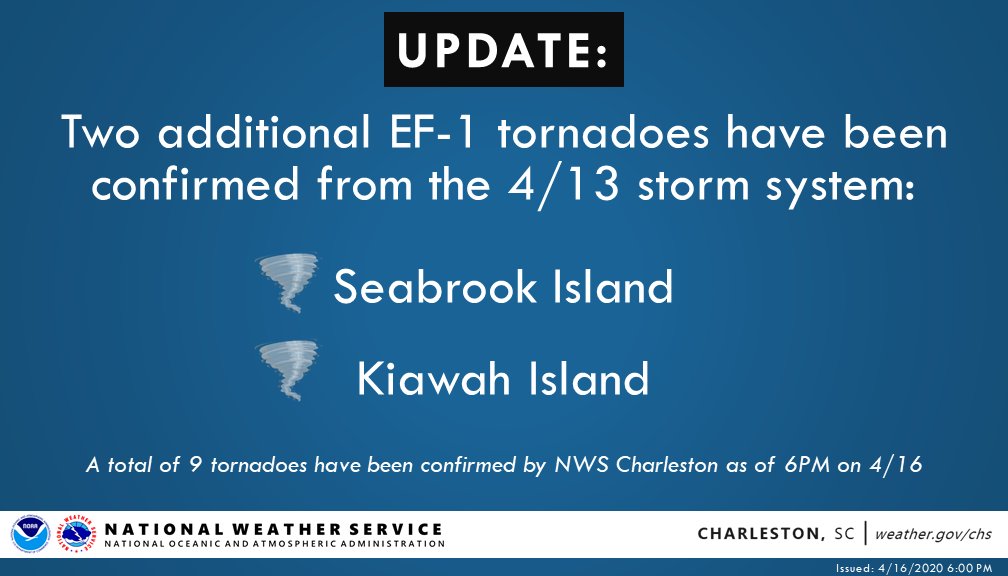 September 6, 2019 -- 2:30 pm
Latest update from Berkeley Electric is that it believes by 8:00 PM this evening, Friday September 6th, the power should be restored to 80-90% of Seabrook Island with the balance restored no later than Saturday morning, September 7th. SIPOA contractors are continuing to remove debris from the roadways on the island. The Town again urges residents not to attempt to return to the island before noon on Saturday, September 7th, to avoid interfering with that effort. For emergency response call 911. For emergency response updates and announcements from the Town of Seabrook Island: Continue to monitor the Town's website (https://www.townofseabrookisland.org); Call the Town's toll-free number (888-314-3177); Follow the Town's TWITTER feed (twitter.com/seabrookislnd87); or Follow the Town's FACEBOOK page (facebook.com/townofseabrookisland) Property Owners with rental guests should forward this notice to their rental guests. The next Town update, if any, is expected to be no earlier than afternoon on Saturday, September 7th, but if circumstances dictate, the Town will issue updates earlier as appropriate. September 6, 2019 -- 12:30 pm
Hurricane Dorian has passed, and our area is in the clear. Gov. McMaster has lifted the evacuation order as of mid-morning on Friday, September 6th. The SIPOA has debris removal crews clearing the roads. That task is anticipated to continue through Saturday, and possibly Sunday. Residents should not plan to return to the island until noon on Saturday, September 7th, in order to avoid interfering with the POA’s cleanup effort. Many hanging limbs have yet to be removed, and there are still several driving hazards on our roads. We have spoken with Berkeley Electric and, as of noon today, they have crews working on the island. Portions of the island have already had power restored and Berkeley anticipates that all areas of the island will have power restored over the next 24 hours. The Town has begun its initial damage assessment which indicates little property damage and some damage to trees. The Town is now at readiness status “Normal Operations”. The State of Emergency declared by the Mayor at the special Town Council meeting held on Tuesday, September 3rd, has been lifted. Town Hall will reopen on Monday, September 9th. For emergency response call 911. For emergency response updates and announcements from the Town of Seabrook Island: Continue to monitor the Town's website (https://www.townofseabrookisland.org); Call the Town's toll-free number (888-314-3177); Follow the Town's TWITTER feed (twitter.com/seabrookislnd87); or Follow the Town's FACEBOOK page (facebook.com/townofseabrookisland) Property Owners with rental guests should forward this notice to their rental guests. The next Town update, if any, is expected to be afternoon on Saturday, September 7th. If circumstances dictate, the Town will issue updates earlier as appropriate to the circumstances. September 5, 2019 -- 1:30 pm
Hurricane Dorian is now a category 2 hurricane and arrived about 30 - 40 miles off the Charleston peninsula at 12:30 pm on Thursday, September 5th. Total rainfall is expected to be about 10” with 3” – 4” more rainfall expected before the storm moves on. Tropical storm force winds (up to 73 mph) with the potential for hurricane force gusts (up to 95 mph) will continue in our area until late Thursday night, September 5th, or early Friday morning September 6th. With midday high tide on September 5th, storm surge inundation will be less than previously expected. Power was lost on Seabrook Island early Thursday morning, September 5th, due to power loss from BEC’s power supplier. BEC did not preemptively cut power to Seabrook Island. St Johns Fire District has requested that residents stay off Johns Island roads with downed trees and power lines blocking roads. Early Thursday morning, September 5th, SJFD was responding to clear a downed tree from Seabrook Island Road. Charleston County EMS has advised that its personnel will not respond to calls when sustained winds reach 40 mph. Charleston County has declared condition yellow, meaning high profile vehicles are to stay off those bridges. Charleston County Emergency Management Department and the Town remain at readiness status "Storm Impacts Occurring or Imminent". The State of Emergency declared by the Mayor at the special Town Council meeting held on Tuesday, September 3rd, remains in effect. Town Hall closed at 2:30 pm on Tuesday, September 3rd, and will remain closed until Monday, September 9th. Evacuated residents should not attempt to return to the Island until the Governor has lifted the evacuation order and the Town has confirmed that it is appropriate for residents to do so. The Town has established criteria for resident return which include availability of emergency services and sewer and water services and completion of debris removal from the roads within the Town. The Town does not expect resident return to begin before noon on Saturday, September 7th. For emergency response call 911. For emergency response updates and announcements from the Town of Seabrook Island: Continue to monitor the Town's website (https://www.townofseabrookisland.org); Call the Town's toll-free number (888-314-3177); Follow the Town's TWITTER feed (twitter.com/seabrookislnd87); or Follow the Town's FACEBOOK page (facebook.com/townofseabrookisland) Property Owners with rental guests should forward this notice to their rental guests. The next Town update is expected to be afternoon on Friday, September 6th, but will issue updates earlier as appropriate to the circumstances. September 4, 2019 -- 4:00 pm
St. Johns Fire District has notified the Town that it has relocated personnel from the Seabrook Island Station. Residents should expect delays in fire and hazard response in consequence of that relocation. Berkeley Electric Cooperative has not yet informed the Town of a decision to preemptively cut power. The Town will publish that determination when notified by BEC. Evacuated residents should not attempt to return to the Island until the Governor has lifted the evacuation order and the Town has confirmed that it is appropriate for residents to do so. The Town has established criteria for resident return which include availability of emergency services and sewer and water services and completion of debris removal from the roads within the Town. For emergency response call 911. For emergency response updates and announcements from the Town of Seabrook Island: Continue to monitor the Town's website (https://www.townofseabrookisland.org); Call the Town's toll-free number (888-314-3177); Follow the Town's TWITTER feed (twitter.com/seabrookislnd87); or Follow the Town's FACEBOOK page (facebook.com/townofseabrookisland) Property Owners with rental guests should forward this notice to their rental guests. The next Town update is expected to be afternoon on Thursday, September 5th, but the Town will issue updates earlier as appropriate to the circumstances. |
Archives
January 2024
Categories
All
|
- About
-
Government
-
Meetings
-
Agendas & Minutes
>
- Town Council
- ATAX Advisory Committee
- Board of Zoning Appeals
- Community Promotion & Engagement Committee
- Environment & Wildlife Committee
- Planning Commission
- Public Safety Committee
- Public Works Committee
- Special Committee on ARPA Expenditures
- Special Committee on Finance
- Special Committee on Short-Term Rentals
- Utility Commission
- Public Comments >
- Short-Term Rental Study >
-
Agendas & Minutes
>
-
Services
- News & Events
- Links
- Contact
 RSS Feed

|
Town of Seabrook Island
2001 Seabrook Island Road Seabrook Island, SC 29455 Phone: (843) 768-9121 Email: [email protected] Town Hall Hours: M-F 8:00 am to 4:00 pm Privacy Policy |
|